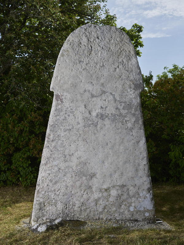
GP 210 Klinte Hunninge II (Klinteberget)


mer grejer
0.0
| Plane | Position | Flip |
| Show planes | Show edges |
Parish Find Location Klinte
Find Location An agricultural field belonging to Hunninge farm (?) in Klinte parish.
Find Context Classification Agricultural Field
Parish Present Location Klinte
Present Location Re-erected at the outer edge of the cliff ʻKlintebergetʼ that rises up just east of Klinte church.
Present Location Classification Landscape
Coordinate Present Location (lat) 6364455
Coordinate Present Location (long) 694552
Material Limestone
Limestone Type coarse reef debris limestone
Geological Group not dated yet geologically
Height 260
Width 165
Thickness 25
Lindqvist Type C/D (ca. 700-1000)E (ca. 1000-1150)
Lindqvist Shape Tall stone
Runic Inscription or not No
Secondary Inscription or Not Yes
Secondary InscriptionMany recent graffiti, in particular names.
Context and Discovery According to Lindqvist (1941/42 II, p. 80), the picture stone GP 209 Klinte Hunninge I was “[…] found in the 1860s during the tillage of a field in Hunninge (Lättstain), a farm belonging to Loggarve, where it is supposed to have been lying together with [Klinte Hunninge] II. From there, the stone [no. I] was transferred to the park in Klintebys, where it still stood in July 1941”, while [stone no. II] “[…] was transported to the outer edge of Klinteberget, just northeast of the church, where it remains to this day” (ibid. 81). GP 211 Klinte Hunninge III “[…] was found at the edge of a small gravel pit just southwest of the estate of Arvid Lerberg to the north of the highway Klinte–Visby […] and was donated to [Gotlands Fornsal]” (ibid.). The find year is not given by Lindqvist. Regarding Klinte Hunninge IV (Klintebys), he notes that “[i]n 1934, this picture stone has been for an unknown number of years in the garden of Klintebys, where it leans against the wall of the local park. It appears natural to suppose that this stone came from Hunninge, also, but no details about its origins could be established” (ibid.). Therefore, Lindqvist calls the stone ʻKlinte sockenʼ (parish, Klinte Kirchspiel), while Jan Peder Lamm listed it as ʻKlinte Hunninge IVʼ. Later, the stone was re-erected, several meters in front of the wall, anchored in the ground with small stones and concrete.
According to a report by Ture Carlsson and a letter by David Rosvall to the National Antiquarian from 1930 (ATA dnr 4546-30, 4794-30), picture stone no. III was registered by Carlsson in the same year and taken from Lerbergʼs garden. Carlsson also notes that no. IV was said to have been discovered ‘one year ago’ at the very same spot. He also mentions that in previous times two more stones (i.e., nos. I and II) had been found at approximately the same place. From there, as Rosvall assumes, they were transported to a field, afterwards re-used as bridge stones, and a lifetime later placed in Klintebys park. In the 1965 inventory about the monuments in Klinte parish (ATA), it is noted that the stones nos. I, II, and IV probably originated from land owned by Klintebys farm, which, however, was situated in the area of Hunninge gård (farm), where they were re-used as bridge stones over a ditch, before they were transferred to the park in Klintebys (“Sägas flyttats från Klintebys ägor å Hunninge, där de uppgivas ha legat som brostenar över diken”). In the 1927 inventory of monuments in Klinte parish (Förteckning över Klinte sockens fasta fornlämningar) kept in ATA, I and II are mentioned as still being situated in Klintebys park.
Consequently, the object biography of the four stones is confusing and their original find spots are impossible to determine. Stone no. I was transferred to Gotlands Museum after the publication of Lindqvistʼs book, no. II is still standing at Klinteberget, no. III is kept in the museumʼs storage in Visborg, and no. IV is still standing in Klintebys park.  GP0209
 GP 211 Klinte Hunninge III
 GP 212 Klinte Hunninge (IV) (Klintebys)
Measurements, Material and Condition The monument has been re-erected on the hill called Klinteberget, rising just behind the church, its root part is anchored in the ground. Lindqvist (1941/42 II, p. 81) describes the stone as follows: “Limestone slab, generally 20–25 cm thick. The obverse is naturally smooth, the narrow sides at places are hewn flat at right angles towards the obverse, but rounded towards the back. The reverse is rough. Remarkable is the linear step that separates the head from the body at an acute angle to the body’s contour. The stone’s height above ground is now 2.6 m. The height of the head is 90 cm, its width is 123 cm; the width of the neck is 113 cm, that of the base 165 cm.” As the spot is a popular destination and barbecue area, the stone is attracting more public attention than other Gotlandic picture stones, and therefore it has frequently fallen victim to vandalism (Widerström 2012a, pp. 38–39; Kitzler Åhfeldt 2013, p. 62; Oehrl 2019a, p. 297. pl. 347a). Already in the earliest documented photos from the early 20th century, recent carvings can be discerned on the stoneʼs surface (ATA Run- och bildstenssamlingen 1718:30). In the 1990s, the stone was restored and the graffiti removed as well as possible. Nevertheless, the stone has been graffitied by carvings time and again. A photo taken in 2011 (ibid.) depicts the monument almost completely covered by modern carved and scratched graffiti, mostly personal names. Meanwhile, it has been restored again; however, since many of the graffiti were engraved quite deeply, some carvings do still remain.
Description of Ornament and Images No remains of the original carvings are visible.
Interpretation of the Imagery No interpretation
Type and Dating Tall mushroom-shaped late-type picture stone, which means Lindqvist’s “Abschnitt” C/D or possibly even E (1941/42 I, p. 44). Since no decoration is preserved on the monument and its surface is so much abraded and damaged, it can only be roughly dated to between the 8th century and around AD 1100.
References Lindqvist 1941/42 II, p. 81, fig. 423; Widerström 2012a, pp. 38–39; Kitzler Åhfeldt 2013, p. 62; Oehrl 2019a, p. 297. pl. 347a.
Påträffades på 1860-talet tillsammans med GP 209 Klinte Hunninge I vid plöjning på åkern Lättstain. Fyndplatsen låg i Hunninge men tillhörde Klintebys. Bildstenen användes senare som brosten över ett dike, innan den restes i parken tillhörande Klintebys, där den stod 1927. Bildstenen restes senare på Klinteberget, där den stod 1941.
Nuvarande lokalisering
I kanten av Klinteberget nordost om Klinte kyrka. Idag är bildstenen täckt av modern graffiti.
Beskrivning
Stor svampformig bildsten (period CD eller E), totallängd 260 cm och största bredd 165 cm. Ingen ristning bevarad på bildstenens mycket skadade yta.
Datering
Dateringen oklar, men den tillhör perioden 700-1000-talen.
Tolkning
Ingen tolkning.
AA
GP0209
TitleGP 210 Klinte Hunninge II (Klinteberget)
Fornsök ID L1976:509
RAÄ ID Klinte 6:1
Jan Peder Lamm ID 154
Lindqvist Title Klinte, Hunninge II
Last modified Apr 23, 2026