
GP 156 Halla Broa XI


mer grejer
0.0
| Plane | Position | Flip |
| Show planes | Show edges |
Parish Find Location Halla
Find Location The Broa (today Broe) necropolis (on a field called ʻBrandenʼ) in Högbro, Halla parish, incorporated into a stone covering of a Viking Age burial.
Find Context Classification Grave
Present Location Classification SHM Storage
Coordinate Present Location (lat) 6581391
Coordinate Present Location (long) 675775
Material Limestone
Height 38
Width 52
Thickness 10
Lindqvist Type B (ca. 500-700)
Lindqvist Shape Dwarf stone
Context and Discovery Lindqvist published 20 picture stones under the name of the farmstead Broa (today Broe), all of which appear to originate from the unusually large Iron Age grave field, which is situated in the south-western part of Halla parish, close to the border to Roma parish, and which had been well known through the ages, first mentioned by Strelow in 1633. The farm belongs to the community of Högbro. Since time immemorial, two important country roads, the road Halla-Viklau and the road Roma-Sjonhem (ʻVisbyvägenʼ) intersect here, where a rise consisting of gravel (the ʻhigh bridgeʼ = Högbro) clearly emerges out of the terrain, leading across the great bog system Romamyr-Stormyr. Both roads in turn are intersected by the railway line Roma-Etelhem. The railway intersects both roads a few hundred metres to the west and southwest of the crossing. During the 19th century, the Högbro elevation was severely diminished and large parts of the Broa necropolis was destroyed by clearing and cultivation, gravel mining, house building, railway and road construction, as well as deliberate grave robbing. Many finds from Broa were sold on the antiquities market during this time, with many acquired by ATA. Unfortunately, the large and highly important cemetery of Högbro-Broa is still not published adequately; its present documentation is incomplete and confusing. The best overview about the history and state of research is given by Lena Thunmark-Nylén (1995–2006 III:2, pp. 621–623; IV:1, pp. 324–347).
The first professional and large-scale excavation took place in 1899, conducted by Hans Hansson, who unearthed 14 graves in a small area next to the intersection, just south of the road Roma–Sjonhem and east of the road to Viklau. One further large-scale excavation was carried out in 1981–82 by Ann-Marie Pettersson, who investigated 120 graves (9 inhumation, 102 cremation, 9 without bones) in a small area (circa 700 m2) about 50 m north of the road Roma-Sjonhem and about 40 m east of the road to Halla (Broe 1:71; see the report compiled by Daniel Langhammer from 2012, RAGU dnr 13/82, 789/84). Apart from that, several minor and poorly documented investigations took place, in the beginning of the 20th century and, in particular, during the 1930s and the early 1940s.
Two large areas are registered by ATA, a burial ground north of the road Roma–Sjonhem (ATA Halla 46:1) and a burial ground south of the road (ATA Halla 48:1). The first one (46:1) covers an area of circa 120 x 110 m (E–W) and contains 66 circular stone settings and 120 investigated flat graves. The other one (48:1) is about 300 x 120 m (N–S) and features 202 circular stone settings. Several other registered monuments, about 15 stone settings, 2 stone kists and 1 gravklot (large spherical stone) seem to belong to the Broa grave field as well (ATA Halla 1:1, 1:2, 74:1, 78:1, 79:1; Roma 31:1, 31:2, 32:1). Thunmark-Nylén (1995–2006 III:2, p. 622) estimates the number of investigated graves alone at about 300 to 400. The actual size and extent of the cemetery, however, remains still uncertain.
The oldest investigated burials can be dated to the Roman Iron Age, some unexcavated stone settings are typical for the Pre-Roman Iron Age. Most of the graves, however, date to the Migration, Vendel and Viking Periods. First and foremost, the grave field is well-known and frequently cited for some particularly important finds such as the decorated horse harness from the equestrian burial discovered in 1899, after which the Broa Style is named (Salin 1922; Thunmark-Nylén 1992; 1995–2006 IV:1, pp. 325–326), the lyre bridge of amber from the same grave (Reimers 1980), and many remarkable finds of glass vessels from all periods (Nylén 1969). Furthermore, thre are several elite warrior graves containing fragments of ring-swords as well as a Vendel helmet (Nerman 1969–1975 I:1, p. 29; II, fig. 601).
The exact location of the find spots of the picture stones is difficult to determine in most cases, and their contexts and relation to the known parts of the cemetery remain unclear. Most of them originate from the railway line and the area west of it (called ʻBrandenʼ) and the rest from the area east of the road to Halla, between the road and the border to Roma (ʻKlosterängenʼ). Lindqvist (1941/42 II, fig. 378) provides a map, which was primarily composed at the National Heritage Board (RAÄ) based on the information kept in ATA. It identifies the location of the find places of the stones as carefully as they could be determined at Lindqvist’s time.
The two pieces of Halla Broa XI were found together with two other picture stones in 1915 by Hans Hanson during the examination of the burial mound Broe VI/1915, which was located on the property of the wheelwright Otto Engström (Thunmark-Nylén 1995–2006 IV:1, pp. 330–331). According to the map provided by Lindqvist (1941/42 I, fig. 378), the find spot is situated just west of the intersection between the road to Viklau and the railway line, north of the border to Möllbos gård, in an area called ʻBrandenʼ, where several other picture stones were found. “Under a low earthen mound, a stone setting was discovered that had a diameter of 4.75 m, was free of earth, and consisted of limestone chunks and boulders. In the upper stone layer, without any apparent order, there were three picture stones, two of which ([Halla Broa] XI and XII) lay at the western edge, the third ([Halla Broa] XIII) at the eastern edge. The latter stone was in a slanted standing position. Under this layer of stones, a circle of limestone slabs, with an outer diameter of 3.5 m, was encountered, with a large boulder in its centre. Under this were another layer of smaller stones and finally the skeleton of a man” (Lindqvist 1941/42 II, p. 64). The inhumation grave was undisturbed, the head of the dead lying in the south. Among the furnishings (SHM 15601:2) were a penannular brooch of bronze, a bronze strap buckle, strap end, and strap joiner, a green glass bead, a knife, and a comb with case (Thunmark-Nylén 1995–2006 IV:1, pp. 330–331; Rundkvist 2012, p. 152–153). The burial can be dated to the 10th century.  GP 157 Halla Broa XII
 GP 163 Halla Broa XIII
Measurements, Material and Condition The limestone slab is up to 10 cm thick, and its obverse is relatively even. “The narrow sides are hewn at right angles towards the obverse to a width of 6 cm and with an approximately 1 cm wide chamfer in between. The reverse is rough and unworked. The preserved fragment, which is composed of two matching pieces, is 38 cm high, measures 52 cm between the upper corners, and 41 cm at the broken edge” (Lindqvist 1941/42, p. 64). The two matching pieces represent the left and the right half of the head of a middle-type picture stone.
Description of Ornament and Images The stone is framed by a border with a coarse step pattern, probably a simplified twisted cord pattern, which is typical for Type B picture stones. The preserved image field depicts a grotesque serpent-like ribbon, curling in the middle, entwining two or three rounded, ring-shaped elements, then tracing the outline of the stone, and finally ending in a slightly thickened tip, presumably a tiny serpent’s head, which is located to the right of the convoluted pattern. It is difficult to understand and to describe this strange motif – Lindqvist (1941/42 II, p. 64) completely avoids describing it and just names it a “Bandmuster” (ʻribbon patternʼ). It probably represents a serpent motif (cf. Larsen 2009, p. 32). Lindqvist (ibid. figs. 386, 391) provides a drawing by Olof Sörling as well as a photo of the unpainted stone (cf. ATA Run- och bildstenssamling 482:9; 879:42; 594:41h; 594:41R; 1718:9a).
Interpretation of the Imagery Two more Type B picture stones bear obscure serpent-like ribbon patterns comparable to Halla Broa XI – GP 335 Rute Ala and GP 297 Unknown Find Spot (see IX). Unambiguous depictions of serpents can be seen on GP 340 Sanda Sandegårda I, GP 368 Stenkyrka kyrka IX, and GP 281 När Smiss 3. See the cited articles for possible interpretations of serpent motifs. For the interpretation of serpents combined with deer motifs, see GP 551 Väskinde Butter.  GP 335 Rute Ala
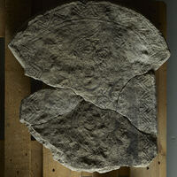 GP 297 Unknown Find Spot
 GP 340 Sanda Sandegårda I
 GP 368 Stenkyrka kyrka IX
 GP 281 När Smiss 3
 GP 551 Väskinde Butter
Type and Dating Middle-type picture stone, which means a Type B ʻdwarf stoneʼ, dating to between AD 500 and 700. The monument belongs to the group of Type B stones featuring a convex head with pronounced corners protruding horizontally. According to Martin Rundkvist’s (2012, p. 159) typology, the stone’s shape represents Type dwarf2/3, belonging to his periods 2 and 3, which he dates to the Early and the Middle Vendel Period. According to Larsen (2009, p. 32), who investigated the stone by 3D scanning, the serpent-like ornament is typical for the 7th century animal style. Due to its shape and the strange, convoluted ribbon pattern or serpent motif, Lindqvist (1941/42 I, p. 37–38) assigns Halla Broa XI to his Alagruppe, named after GP 335 Rute Ala, which bears a very similar image. During Lindqvistʼs time, these two monuments were the only known picture stones decorated in this way. An even better parallel, however, is represented by the recent find GP 297 Unknown Find Spot. GP 335 Rute AlaGP 297 Unknown Find Spot
References Lindqvist 1941/42 II, p. 64, figs. 386, 391; Larsen 2009, p. 32, fig 28; Rundkvist 2012, p. 152–153 cat. no. 13.
Bildstenen påträffades 1915 som sekundärt använt byggnadsmaterial i en gravhög från 900-talet på gravfältet Broa i Halla socken.
Nuvarande lokalisering
Statens Historiska Museums magasin, Tumba
Beskrivning
Två fragment av en dvärgsten (typ B), 38 x 52 cm, med kantdekorationer och ett bildfält med troligen en slingrande orm.
Datering
Dateringen kan inte anges närmare, men bildstenen tillhör perioden 500-700.
Tolkning
Ingen tolkning.
AA
TitleGP 156 Halla Broa XI
Jan Peder Lamm ID 111
Statens Historiska Museer ID 15601
Lindqvist Title Halla, Broa XI
Last modified Apr 21, 2026

