GP 146 Halla Broa VIII


mer grejer
0.0
| Plane | Position | Flip |
| Show planes | Show edges |
Parish Find Location Halla
Find Location The Broa (today Broe) cemetery in Högbro, Halla parish, discovered in an area called ʻBrandenʼ.
Find Context Classification Grave-field
Present Location Classification Gotlands Museum Magasin Visborg
Coordinate Present Location (lat) 6390259
Coordinate Present Location (long) 695514
Material Limestone
Limestone Type coarse reef debris limestone
Geological Group Klinteberg Formation (30%)
Height 40
Width 30
Thickness 7
Lindqvist Type B (ca. 500-700)
Lindqvist Shape Dwarf stone
Runic Inscription or not No
Context and Discovery Lindqvist published 20 picture stones under the name of the farmstead Broa (today Broe), all of which appear to originate from the unusually large Iron Age grave field, which is situated in the south-western part of Halla parish, close to the border to Roma parish, and which had been well known through the ages, first mentioned by Strelow in 1633. The farm belongs to the community of Högbro. Since time immemorial, two important country roads, the road Halla–Viklau and the road Roma–Sjonhem (ʻVisbyvägenʼ) intersect here, where a rise consisting of gravel (the ʻhigh bridgeʼ = Högbro) clearly emerges out of the terrain, leading across the great bog system Romamyr-Stormyr. Both roads in turn are intersected by the railway line Roma–Etelhem. The railway intersects both roads a few hundred metres to the west and southwest of the crossing, respectively. During the 19th century, the Högbro elevation was severely diminished and large parts of the Broa cemetery were destroyed by clearing and cultivation, gravel mining, house building, railway and road construction, as well as deliberate grave robbing. Many finds from Broa were sold on the antiquities market during this time, with many acquired by ATA. Unfortunately, the large and highly important cemetery of Högbro-Broa is still not published adequately; its present documentation is incomplete and confusing. The best overview about the history and state of research is given by Lena Thunmark-Nylén (1995–2006 III:2, pp. 621–623; IV:1, pp. 324–347).
The first professional and large-scale excavation took place in 1899, conducted by Hans Hansson, who unearthed 14 graves in a small area next to the intersection, just south of the road Roma-Sjonhem and east of the road to Viklau. One further large-scale excavation was carried out in 1981–82 by Ann-Marie Pettersson, who investigated 120 graves (9 inhumation, 102 cremation, 9 without bones) in a small area (circa 700 m2) about 50 m north of the road Roma–Sjonhem and about 40 m east of the road to Halla (Broe 1:71; see the report compiled by Daniel Langhammer from 2012, RAGU dnr 13/82, 789/84). Apart from that, several minor and poorly documented investigations took place, in the beginning of the 20th century and, in particular, during the 1930s and the early 1940s.
Two larger areas are registered by ATA, a burial ground north of the road Roma-Sjonhem (ATA Halla 46:1) and a burial ground south of the road (ATA Halla 48:1). The first one (46:1) covers an area of circa 120 x 110 m (E–W) and contains 66 circular stone settings and 120 investigated flat graves. The other one (48:1) is about 300 x 120 m (N–S) and features 202 circular stone settings. Several other registered monuments, about 15 stone settings, 2 stone kists and 1 gravklot (large spherical stone) seem to belong to the Broa grave field as well (ATA Halla 1:1, 1:2, 74:1, 78:1, 79:1; Roma 31:1, 31:2, 32:1). Thunmark-Nylén (1995–2006 III:2, p. 622) estimates the number of investigated graves alone at about 300 to 400. The actual size and extent of the cemetery, however, remains uncertain.
The oldest investigated burials can be dated to the Roman Iron Age although some unexcavated stone settings are typical for the Pre-Roman Iron Age. Most of the graves, however, date to the Migration, Vendel and Viking Periods. First and foremost, the grave field is well-known and frequently cited for some particularly important finds such as the decorated horse harness from the equestrian burial discovered in 1899, after which the Broa Style is named (Salin 1922; Thunmark-Nylén 1992; 1995–2006 IV:1, pp. 325–326), the lyre bridge of amber from the same grave (Reimers 1980), and many remarkable finds of glass vessels from all periods (Nylén 1969). Furthermore, several elite warriorsʼs graves containing fragments of ring-swords as well as a Vendel helmet (Nerman 1969–1975 I:1, p. 29; II, fig. 601).
Regarding the picture stones, the exact location of the find spots is difficult to determine in most cases, and their contexts and relation to the known parts of the cemetery remain unclear. Most of them originate from the railway line and the area west of it (called ʻBrandenʼ) and the rest from the area east of the road to Halla, between the road and the border to Roma (ʻKlosterängenʼ). Lindqvist (1941/42 II, fig. 378) provides a map, which was primarily composed at the National Heritage Board (RAÄ) based on the information kept in ATA. It identifies the location of the find places of the stones as carefully as they could be determined at the time of Lindqvist.
“Found by the butcher Petterson during construction of his new house on the so-called ʻBrandenʼ, together with [Halla Broa] VII and IX as well as 24 limestone balls [gravklot] (GF 1679–1702) and several other antiquities (GF 1704–1710)” (Lindqvist 1941/42 II, p. 62). The find spot is situated, according to the map provided by Lindqvist (1941/42 I, fig. 378), west of the road to Viklau, south of the railway line, in an area belonging to the farmstead Möllbos gård (not Broa/Broe). Information about the find year is not available.  GP 142 Halla Broa VII
 GP 149 Halla Broa IX
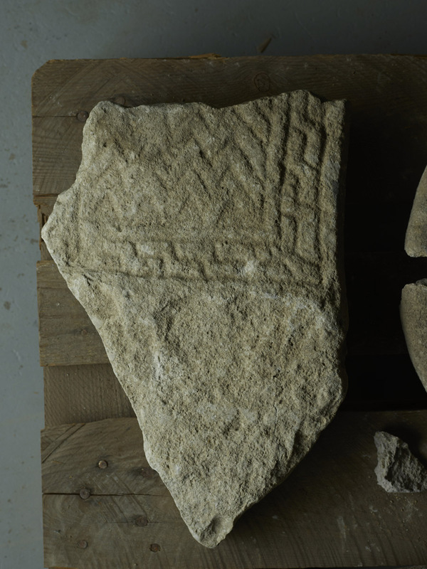
Measurements, Material and Condition “Limestone slab, 5–6 cm tick above the root, which is slightly rougher [compared to the decorated upper part of the stone]. Both broad sides are hewn above the root, the undecorated face less carefully. The narrow side is hewn at right angles towards the broad sides, with chamfers on both sides. Height of the fragment 40 cm, 18 cm of which above the root. The width of the body at the base once was about 30 cm (of which 26 cm are preserved)” (Lindqvist 1941/42 II, p. 63). Only the stone’s base is apparently completely preserved, the upper part and the head are lost. The root is partly broken off as well. The decoration is executed in a relatively sophisticated technique, achieving a bas-relief-like effect (which is discernible on the photo provided by Lindqvist [II, fig. 390, cf. ATA 1751:24a] but does not become apparent in Sörling’s drawing kept [at ATA]). Therefore, the ornament is very easily visible. There seem to be no considerable traces of weathering.
Description of Ornament and Images “Decorated with carved lines with a depth of approximately 3 mm and rounded bottoms that formed a border filled with a simplified twisted cord pattern. In the same way, the surviving lower part of the field is filled with parallel zigzag lines. Remains of the vertical line delineating this field towards the left are preserved at the bottom. The triangular areas below the lowermost zigzag line are chiselled” (Lindqvist 1941/42 II, p. 63).
Interpretation of the Imagery No interpretation
Type and Dating The small size, the massive root, and the typical simplified twisted cord pattern, which looks like a primitive step pattern, clearly indicate a middle-type picture stone, which means a Type B dwarf stone, dating to between AD 500 and 700. Zigzag ornamentation comparable to the pattern on Halla Broa VIII can be seen on GP 143 Halla Broa I, which, according to Lindqvist, belongs to the ʻStenstu groupʼ. The best match, however, depicting both the zigzag decoration in the lower field and remains of the simplified twisted cord border is represented by the fragment GP 93 Gammelgarn Högstens, which Lindqvist assigned to his ʻStenstu groupʼ as well.  GP 143 Halla Broa I
 GP 93 Gammelgarn Högstens
References Lindqvist 1941/42 II, p. 63, fig. 390; Guber 2011, p. 125 cat. no. 32.
Bildstenen påträffades vid ett husbygge på ett område som tillhörde gården Möllbos, nära järnåldersgravfältet vid Broa i Halla socken.
Nuvarande lokalisering
Gotlands museums magasin, Visborgsslätt.
Beskrivning
Fragment av dvärgsten (typ B), 40 x 30 cm, med kantdekorationer och rester av ett bildfält med zigzag-linjer.
Datering
Dateringen kan inte anges närmare, men bildstenen tillhör perioden 500-700.
Tolkning
Ingen tolkning.
AA
TitleGP 146 Halla Broa VIII
Gotlands Museum ID GFC1677
Jan Peder Lamm ID 108
Lindqvist Title Halla, Bros VIII
Last modified Aug 26, 2025